Posts

Mt. Baldy

Image
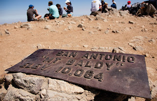
January 9, 2021: Mt. Baldy Chetan Kolluri, 07 Mt.Baldy ,  CC BY-ND 2.0 A big run today took me up into the Angeles National Forest. I climbed to the town of Mount Baldy. When I was in my first year of medical school a group of us camped there and hiked up the actual Mount Baldy, Also known as Mount San Antonio, this mountain is 10,066 feet high, and it’s the highest mountain in the San Gabriel Mountains. It was freezing at the top!  The Angeles National Forest is a world of difference from dusty dry Los Angeles. Pine trees, rushing streams, mountain trails and quiet empty spaces are all within an easy drive of the city. Instead of a bachelors party, my groomsmen and I did a hike in this amazing forest. 

San Gabriel Valley

Image
January 3, 2021-January 7, 2021: San Gabriel Valley After passing downtown LA, I  headed up into Alhambra and San Gabriel Valley. I passed through the predominantly Chinese suburbs of Monterey Park, Rosemead, and Temple City. In the latter,my cousin’s friend had a great little bistro restaurant called Crumbs that was open for only a short time. Such wonderful lamb chops! Person-with-No Name, Mt Baldy from Santa Fe Dam. [163] , CC BY 2.0 It took a few days to traverse the San Gabriel Valley. One day, I passed the Santa Fe Dam Recreation Area, where I used to go run when my wife was working as a tutor in the area. That place had miles of open trail but it always smelled of the Miller brewery up near the northern end of the park. By January 7, I had reached the La Verne-Pomona area where I took a day off because I had a real life meeting.

City of Los Angeles

Image
January 2, 2021: Los Angeles Proper Ron Reiring, My Los Angeles , CC BY 2.0 Day 2 was a 13 miler and I passed through Miracle Mile, Koreatown, Downtown LA, Chinatown. I ran right by where I used to work at the Los Angeles Department of Public Health. I ran near Dodger Stadium then shortly after crossing the Los Angeles River on the North Spring Street Viaduct, I ended up in Lincoln Heights.  KCET Departures, LA River Bridges - N. Spring Street, CC BY-NC-ND 2.0

Santa Monica Pier through West LA

Image
Stage 1: Santa Monica Pier to Victorville, CA http://www.gmap-pedometer.com/?r=7553821 I decided to split the route into stages to make each more achievable and to give me a mental idea of where I was. Stage 1 would take me from the Pacific Ocean at the Santa Monica Pier to Victorville, CA.  January 1, 2021: Santa Monica and Westside Santa Monica Pier , Matt Kieffer, CC BY-SA 2.0 I started off actually a little bit into the Pacific Ocean at the very end of the Santa Monica Pier. Despite living in Los Angeles for 8 years, I don’t think I ever actually made it onto the pier. I ran by it many times on the beach path but I wasn’t ever that interested in the amusement park. I had no idea that on the other side of the amusement park was this fishing platform where I would start this virtual run. I should have paid more attention to writing along the first week of this experience because the run took me through many familiar places. On day 1 I proceeded east along West Pico Blvd, a street tha

Stage 0: Planning to Run across America

Image
Planning to Run across America The year of coronavirus was a big running year for me. I ran in the Great Virtual Race across Tennessee (GVRAT). This was 600 miles from May to August. When I got done with the race I figured out that if I kept going at a reasonable pace, I would be able to run the year in miles. I set the new goal of 2020 miles in 2020 and reached this in early December. I finished the year with 2177 miles. This made me think about what it would take to run across the whole continental USA.  There is a long history of people running across the country. I read about an early race in a book about C.C. Pyles where people averaged 50+ miles a day in antiquated footwear and clothing.  There are many routes across the country but since my attempt would be a virtual run, I chose to start from near where we used to live in Los Angeles and end near where we lived in Boston. According to Google Maps, it would take 2992 miles to get there on foot. If I put in 40 miles per week, tha